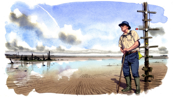
Walking Britain’s most perilous path

Simply sign up to the Life & Arts myFT Digest -- delivered directly to your inbox.
“Danger,” declares one sign. “Warning: this area may contain unexploded objects,” says another. “Any person who finds any shot, shell, bomb or any unidentifiable explosive object, should report the finding.”
The signs offer an unlikely start to a public footpath — but then nothing about the Broomway is “normal”. It is less a track than a sequence of compass bearings. Though marked on maps as a public right of way, it is invisible to the naked eye. For much of each day it is submerged. It has been called the most perilous path in Britain, but was starkly beautiful when I walked it with Brian Dawson, who, at 76, is one of the last guides to the ancient route.
The Broomway, first recorded in 1419, runs for six miles across Maplin Sands, parallel to the Essex coastline and almost half a mile offshore. For much of its existence it provided the only route for man or cart to the farms of Foulness (a low-lying island separated from the mainland by narrow creeks). In 1915 the Ministry of Defence turned the area into an artillery testing range. In 1922 the MoD built a bridge to Foulness across Havengore Creek, but it could not remove that ancient right of way and must still, reluctantly, allow public access to it most weekends.
Some friends and I met Dawson at its start, Wakering Stairs, just outside Shoeburyness and some 40 miles east of London, at 10am on a brilliantly clear and sunny Sunday earlier this month. We walked down an old, crumbling causeway on to a great expanse of wet sand that stretched away into the far distance, bare and boundless, beneath a vast blue sky.
We could not see the sea itself, but to our right the wreck of a boat protruded from the sandy flats. Before us, in the distance, we could make out second world war artillery platforms guarding the mouth of the Thames estuary, and wind farms off the Kent coast, and tiny tankers and container ships seemingly floating in some shimmering mirage on the horizon.
Low tide was at 12.30pm, giving us four hours to get to Foulness and back. Though Dawson occasionally finds unexploded ordnance, that is the least of the Broomway’s dangers. When the tide turns, the water races in faster than a man can run. The Foulness Burial Register alone records 66 bodies recovered from the sands since 1600. “You’ve got to understand. That’s the North Sea out there, and this is the first place it makes landfall,” our genial guide observed as he led us eastwards to a tiny island of cordgrass.
There are other perils too. The Broomway was once marked by “brooms” — posts with bundles of sticks on top that were stuck in the sand every 30 paces, but no longer. On foggy days, or when sea mists roll in, it is easy to lose all sense of direction in this featureless expanse. Dawson assiduously studies the weather forecasts. “I only decide the day before whether to go ahead,” he said as he turned north-eastwards towards the “Maypole” — a lone navigation post with several stubby crossbars.
From there we splashed northwards on a base of solid sand, across the empty mouth of Havengore Creek and beside a shoreline punctuated by mysterious towers and bunkers. We stuck close to Dawson because there are also quicksands on Maplin Sands, and muddy bogs known as the Black Grounds, and shell holes filled with water or soft sand into which humans can allegedly vanish. “If I disappear, turn round,” Dawson quips.
After 90 minutes or so we reached Asplins Head, where another crumbling causeway leads on to Foulness past old concrete blocks and rusting ironmongery. Access is forbidden except on the first Sunday of each summer month, which this was, but we lacked the time to reach the island’s last surviving village, Churchend, and get back before the tide turned.
We instead retraced our steps to Wakering Stairs and drove across the bridge to Churchend. Like the Broomway, it is unique. Its church, shop, post office, school and pub all closed years ago, but some 150 people still live there or on neighbouring farms, requiring special passes to come and go and seemingly unbothered by the batteries and ranges all around them.
After a couple of hours we drove back across the bridge. Havengore Creek, bare mud when we arrived, was now full of water, and with frightening speed the Broomway had vanished beneath the sea.
Details
For more information see broomway.org.uk. For dates and times of public access to the Broomway and Foulness call Qinetiq, which manages the range for the MoD, on 01702 383211. Brian Dawson occasionally guides groups; he does not charge but invites guests to make a £15 donation to the Foulness Heritage Centre; he can be reached via email at b.dawson540@btinternet.com
Follow @FTLifeArts on Twitter to find out about our latest stories first. Subscribe to FT Life on YouTube for the latest FT Weekend videos
Letter in response to this article:
MoD was created in 1964 / From Peter Macfarlane, Romsey, Hants, UK
Comments